 |
 |
 |
|---|
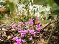
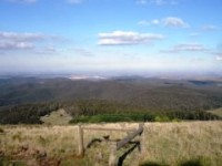
Lerderderg State Park - land of forests, wildflowers and panoramic views. Pictures by Bancoora.com.
The Lerderderg State Park is located approximately 60 kilometres to the west of Melbourne. It has limited mountain biking options due to the management plan of the park which restricts riding to a few trails which are largely fire trails with a bit of singletrack. Having said that, the trails are good being rough in nature and have spectacular views which are complemented in the wildflower season with spectacular displays of wild flowers particularly in the Pyrete Range part of the park.
| Blackwood Ranges | Beginning at Swans Road north of Bacchus Marsh, a long constant climb on rough fire trails all of the way up to Mount Blackwood. Spectacular gorge views half way up are further complemented by 270 degree views at the summit of Mount Blackwood. |
|---|---|
| Djerriwarrh Loop | Loop located in the Pyretes Range (eastern) section of the Lerderderg State Park. |
| Gisborne Loop | A 33 km loop that starts in Gisborne and is largely single trail (road side and off road). Can be supplemented with further road side trail as well to make even longer. |
| Hobbs Road | A roadside trail that is good for a training ride to get the kilometres up or get the kids used to a gravel trail. |
| Long Forest Road | A very easy single track suitable for younger kids starting out. Hidden amongst the roadside vegetation. |
| Mount Blackwood Road | Mount Blackwood Road is included as it allows people riding from Bacchus Marsh to get to the Wombat State Forest and head further up to places like Blackwood. Whilst largely a gravel road, it does have small sections of motor bike single track alongside plus a few small trails off to the south which are outside the conservation zone of the park. |
| Mt Sugarloaf - Antimony Mine | Located in the Pyretes Range (eastern) section of the Lerderderg State Park, this ride is a combination of big climbs on loose rock fire trails with spectaular views before descending down into the single track along a remote creek valley to the old antimony mine ruins. There are also some notes on the potential for north to south crossing of the park. I have seen references to this being done in half a day or so by MTB. This is a ride which I haven't completed yet. It traverses the Pyretes Range from north to south and needs to be done as a shuttle ride or a train station to train station ride. Can guarantee some hike a bike sections with this one. |
| Pyretes Range Map (Printable) | Map of the Lerderderg Park (Pyretes Range Section) for Mt Sugarloaf and Antimony Mine ride. May download to your Downloads folder. |
| Lerderderg Park Map (Printable) | Map of the Lerderderg Park (western section) for Blackwood Ranges ride. May download to your Downloads folder. |
| Lerderderg and Pyretes Range Maps (Digital) | Trail maps for both parks can be obtained from Avenza maps along with app. This is the Parks Victoria map and has GPS functionality for out on the trail and can be downloaded to Android and ioS devices. Does not need internet availability once downloaded. Use "Lerderderg" as search term or pan on map to relevant park and select. Maps are free. |
| Blackwood Ranges | Click on link for map showing how to get there. |
|---|---|
| Hobbs Road | Click on link for map showing how to get there. |
| Long Forest Road | Click on link for map showing how to get there. |
| Mt Sugarloaf - Antimony Mine | Click on link for map showing how to get there. |
 |
Local area information can be obtained at the Parks Victoria Lerderderg Park (Western portion) webpage and Parks Victoria Lerderderg Park (Pyrete Range) webpage.There are limited facilities in the park area and Bacchus Marsh, Gisborne and Melton are the closest main centres. |
|---|---|
 |
The Lerderderg Park does not have a visitor information centre. |